Air Navigation Pro
Developed by Xample Sarl | Last updated: May 19, 2024

Air Navigation Pro is a navigation app, developed by Xample Sarl, available on iOS and Android since its release in January 2009. The updated version 8.3.350 is now available to download, compatible with iOS 13.0+ and Android 10+. Before downloading this app, let's quickly review what Air Navigation Pro has to offer.
About Air Navigation Pro
Discover our flight planning & real-time navigation app for free for 28 days!
- Everything you need to fly around the world
- Plan your flight in a few minutes
- Fly relaxed with up-to-date information
Air Navigation Pro is a high-quality flight assistant app for pilots worldwide. Benefit from the following main features:
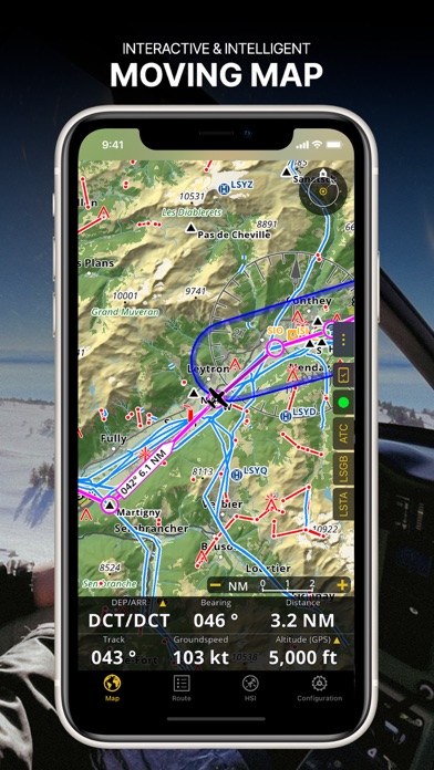
MOVING MAP
Plan and navigate using our interactive moving map. Choose between aeronautical charts, satellite or our vector map as a background. On top of that, the moving map displays waypoints, NOTAM, obstacles and airspaces from our comprehensive, always up-to-date worldwide aeronautical database. Tap on any waypoint directly on the map to easily create a route. Personalize the values shown on the navbar to have exactly the information you need: altitude, vertical speed, bearing, distance to the next waypoint, ETA calculations, etc. Choose the airport departure and arrival procedures for your route to have them also displayed on top of the moving map.
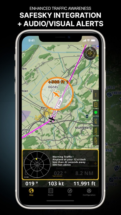
ENHANCED TRAFFIC AWARENESS
Get visual and audio alerts in all languages for nearby conflicting traffic. Choose your preferred traffic icon between generic, aircraft or TCAS symbols. Your safety is important to us, which is why we partnered with SafeSky to ensure our users have live traffic data during their flight. Benefit from the native integration with SafeSky included in our new Smart Lite, Smart Classic and Smart Advanced subscriptions—a two-in-one package!
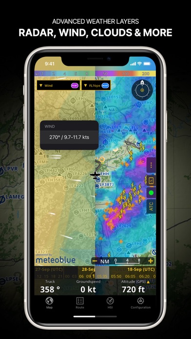
ADVANCED WEATHER LAYERS
In addition to the basic weather reports & forecast of winds, TAF/METAR and GAFOR for your flight in the Briefing section, subscribers of the Smart Advanced plan can activate see-through weather layers on top of the moving map. Available layers include rain radar, wind, pressure, clouds and rain, visibility, gust and for Germany, Switzerland, Austria and the Balkans, we also have GAFOR. Tap on any point on the map to see the weather information for that area. Review the weather forecast for up to three days ahead.
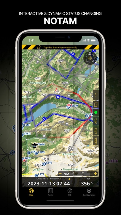
NOTAM
After creating your route, set the departure time in the future to have the moving map display the NOTAM active for that specific time. NOTAM on the map change color dynamically based on their status.
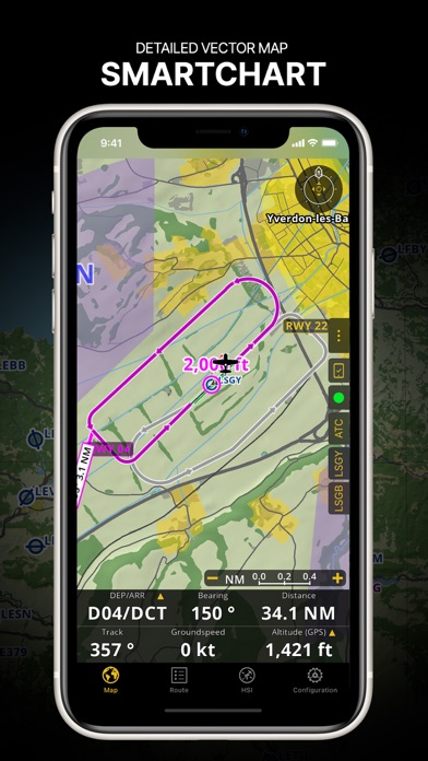
SMARTCHART
Our cutting-edge SmartChart is a highly detailed and intelligent vector-based map that adapts to your needs, providing you with adequate information at any zoom level. The SmartChart optimizes the display of shadows to easily distinguish between valleys and mountains, and the text remains perfectly aligned, guaranteeing optimal readability. Including the latest significant improvements with forests and detailed airport information.
ELEVATION PROFILE & 3D VIEW
Enable the profile view below the navbar for enhanced situational awareness of the elevation ahead of you or along your route. Choose the corridor width between 0 to 5 NM and overlay options: airspaces, NOTAM, obstacles, wind components, populated places, etc. Switch to the synthetic 3D view for additional terrain information, plus an artificial horizon with altitude and vertical speed indicators. The 3D function can also be used to pan around while preparing for your flight. Activate TAWS on the moving map as well as on the 3D view.
AERONAUTICAL CHARTS & APPROACH CHARTS
We offer the most extensive worldwide catalog of aeronautical charts, including the ICAO charts. Have the georeferenced approach charts displayed on top of the moving map or the 3D view.
BRIEFING
Prepare your flight with our briefing section by creating documents with NOTAM and weather charts & stations relevant to your planned route. Optimize time by creating an aircraft profile which will be used in the Briefing section to pre-fill for you the ATC Flight Plan and calculate the W&B.
AND SO MUCH MORE!
Please note that WiFi-only devices do not include an internal GPS receptor; for these devices, an external sensor is required. Refer to our user manual on our website: www.airnavigation.aero for more information.
What's new in version 8.3.350
Happy New Year! Thank you for your continuous support for another year!
Check out what's new in this version:
- Map Annotations: Now, you can highlight, draw geometrical figures and write with a marker directly on the map, allowing you to create your own data like user airspaces. Activate it on Map Options - Guides and work in Edit Mode.
- Enhanced Map Resolution: We've boosted the resolution of the vector map at high zoom levels, ensuring a clearer navigation experience.
- Improved Dark Mode Handling: Switch effortlessly between Light, Dark or let the app adapt automatically. Find the new Color Theme menu on Map Options.
- Seamless Cross-Platform Synchronization: Enjoy a smooth experience between your mobile device and the new desktop version!
Start the year on the right track with our first update of 2024, because great journeys begin with great navigation!
Download the Air Navigation Pro App
Air Navigation Pro has an IPA/APK download size of 194 MB on its latest version. Air Navigation Pro is FREE to download. Ready to install? Ensure you have at least 233 MB of storage space available, then tap the button or scan the QR code below to start the download process!
Ranking History in App Store (U.S)
Changelog
Compatibility
- iPhone 15, 15 Plus, 15 Pro, 15 Pro Max
- iPhone 14, 14 Plus, 14 Pro, 14 Pro Max
- iPhone 13 Pro Max
- iPhone 12 Pro
- Old devices: iPhone X/SE/8/7/6
- iPad Pro
- iPad Mini

Review: Can’t accurate location in flight.
Can’t accurate location in flight.
By Min maw
Review: Worked fine until the recent update
App has worked fine for years. It recently updated, and now it crashes as soon as open it. Sometimes it...
By Annoyed20232023
Review: Hi
First let me have especial tank for your best app, then if it’s possible active 3D navigation and all...
By 214ASafeman
Review: ADS missing
Not compatible with SkyRadar Raddena. Rest of app is very good
By Cricasa
Review: Very good!
I have tried several apps and this is the best one even though I can not take advantage of the...
By RICARDO4G
