HuntStand
Developed by TerraStride Inc | Last updated: June 10, 2024


HuntStand is a sports app, developed by TerraStride Inc, available on iOS and Android since its release in December 2013. The updated version 7.6.7 is now available to download, compatible with iOS 16.0+ and Android 10+. Before downloading this app, let's quickly review what HuntStand has to offer.
About HuntStand
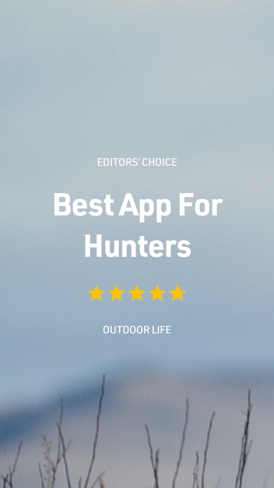
Recognized by Outdoor Life Magazine as the Best Hunting App available. With over 6 million downloads, HuntStand is North America’s #1 Hunting & Land Management App. Map and navigate your hunting areas in real 3D, view detailed hunting weather and game movement forecasts, access private and public property info, view 5 years of historical satellite imagery by month and so much more. Try HuntStand for free today, and unlock even more powerful features through our membership options.
What Sets HuntStand Apart?
• Rich 3D Mapping: Navigate your hunting terrains in dynamic 3D for precision planning.
• Group Hunt Areas: Collaborate seamlessly, sharing hunt areas with hunting buddies, lease partners, and family members.
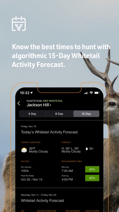
• Advanced Weather & Game Movement Forecasts: The latest science informs our exclusive 15-Day Whitetail Activity Forecast specific to your Hunt Area. Know when to hunt.
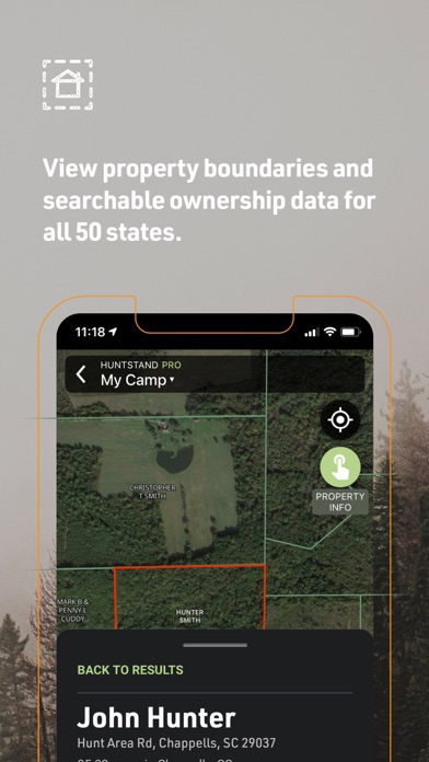
• Extensive Property Line Insights: Dive deep into private and public property details with nationwide private property boundaries and curated public land and public hunting land maps.
• Nationwide Rut Map: The only nationwide county-level rut map available, providing rut dates for all phases. Visualize comprehensive rut data through a color-coded map to make sure you’re putting the right strategies to work.
With a Free Account, Enjoy:
• High-Resolution Aerial Imagery: Craft detailed maps of your hunting areas.
• Stealth Cam & Muddy Trail Camera Integration: View and manage your trail cameras effortlessly within the app.
• Comprehensive Weather Forecasts: Stay ahead of the weather and optimize your hunting plans.
• Advanced Stats: Delve into personal harvest and sighting analytics for richer insights.
• Nationwide Crop History Maps: Access current and historical crop data to refine your strategy.
• Stand Reservation Management: Systematically organize stand hunting times within shared hunt areas.
Upgrade Options - HuntStand Pro & HuntStand Pro Whitetail:
HuntStand Pro Benefits:
• Nationwide Property Boundaries: Offering coverage across the U.S. and most of Canada, with unlimited U.S. property ownership searches.
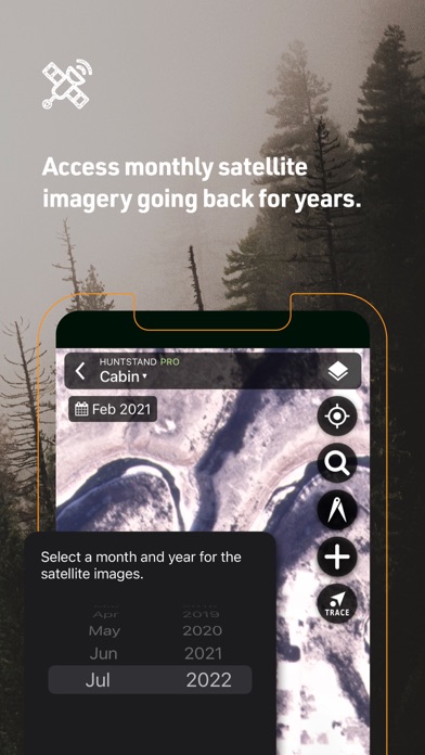
• Recent Satellite Imagery: Retrace changes in your hunting ground with monthly satellite imagery, dating back to 2018.
• Real 3D Maps: Dive into your maps in full 3D on both mobile and desktop.
• Land Data Layers: A spectrum of details including hunting lands, public lands, crop history, tree cover, and more.
• Real-time Weather Radar: Anticipate weather changes with real-time updates.
HuntStand Pro Whitetail Exclusives:
• All the features of HuntStand Pro.
• Nationwide Rut Map: Boasting the most comprehensive county-level rut data visualized on a color-coded rut map.
• Whitetail Activity Forecast: Get a grip on deer movement with a 15-day predictive outlook and in-depth metrics.This exclusive feature uses data from state agencies and top whitetail scientists.
• Whitetail Habitat Map: Gain unparalleled insights into top habitats optimal for white-tailed deer. Find new hunting areas with ease!
Billing & Subscription: Charges apply to your iTunes Account upon purchase confirmation.
Privacy Policy: https://huntstand.com/privacy
Terms & Conditions: https://huntstand.com/terms-and-conditions
What's new in version 7.6.7
What's New in Version 7.6.7:
We're always working hard to improve your experience with Huntstand.
Bug Fixes:
In this update, we've addressed some issues that affect users with large hunt areas having issues with group sharing and syncing.
Performance Improvements:
We're continuously making changes to increase performance on all devices.
Download the HuntStand App
HuntStand has an IPA/APK download size of 116 MB on its latest version. HuntStand is FREE to download. Ready to install? Ensure you have at least 139 MB of storage space available, then tap the button or scan the QR code below to start the download process!
Ranking History in App Store (U.S)
Changelog
Compatibility
- iPhone 15, 15 Plus, 15 Pro, 15 Pro Max
- iPhone 14, 14 Plus, 14 Pro, 14 Pro Max
- iPhone 13 Pro Max
- iPhone 12 Pro
- Old devices: iPhone X/SE/8/7/6
- iPad Pro
- iPad Mini
Review: Great for navigation
On a club of 6500 acres this app is a great tool to place and locate stand sights. With the satellite...
By Squealer killer
Review: Does what it’s supposed to.
I have both hunt stand & ONX both are great. I prefer HuntStand.
By asdhjdleh 2759(!/72
Review: Very good
This app has almost everything for hunting trips.
By Blox ben
Review: Awesome app
Great app. Lots of information
By Florida Family Fan
Review: Great
Very useful to see what to do in a bad hunting situation
By jpc123tka